
 Blender
 Cinema 4D
 Arnold
 3ds Max
 Houdini
 V-Ray
V-Ray Maya
Maya Unreal Engine
 Nuke
NukeWhat is a Point Cloud? Meaning, Uses, and Rendering Explained
 Ryan Thompson
Imagine you are assigned the task of capturing every single detail of a physical space. From the intricate curves of a historical monument to the complex pipes in an industrial warehouse, there is nothing you can miss. If you use traditional photography, it will only give you a flat view, and you will struggle to visualize the true depth.
This is where 3D point cloud technology comes in, using a point cloud scanner to capture millions of data points in a 3D coordinate system. So, understanding point cloud is the first step towards mastering modern spatial mapping. This guide explores the essential software and hardware for point cloud solutions that turn raw coordinates into stunning, usable 3D environments.
What Is a Point Cloud?
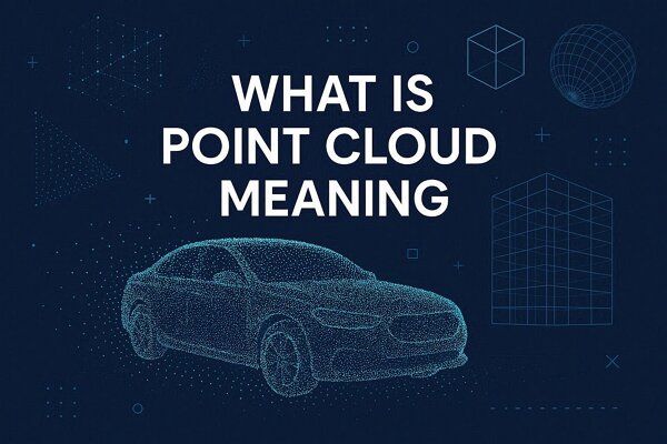
The point clouds are a collection of data points in space that are usually produced by 3D scanners. Each point represents a single X, Y, and Z geometric coordinate on a physical surface. When millions of these points are gathered together, they form a highly detailed cloud that resembles the shape of the object or environment being scanned.
How Point Cloud Data Is Created?
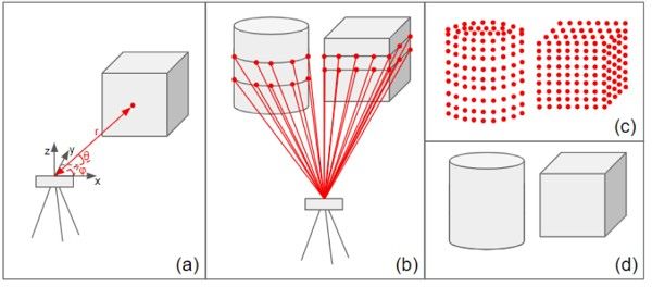
Ideally, there are 3 primary methods used to generate these datasets, and they are mentioned below in detail:
- LiDAR Scanning: The 3D point cloud is created by hitting a surface with laser light and measuring the time it takes for the reflected light to return to the scanner.
- Photogrammetry: This method uses point cloud software to analyze overlapping photographs taken from different angles, triangulating the points to define 3D space.
- Depth Sensors: Often found in modern mobile devices, these sensors use infrared light to map nearby objects in real-time. Through this, it provides instant point cloud data for AR applications.
Key Techniques in Point Cloud Rendering
Rendering the point cloud data made from a point cloud scanner or software is a resource-intensive process. This is because graphics cards mainly optimize triangle rendering, not dense clouds of individual points. Thus, to turn a cloud into a solid point cloud model, here are 5 techniques that are used:
1. Splatting (Surface Reconstruction)
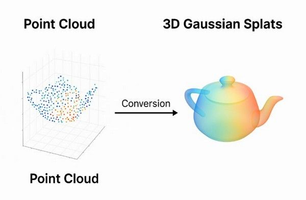
Since points have no actual surface area, a raw point cloud can look like a semi-transparent mist. So, Splatting replaces each point with a small, circular or elliptical disc called a “Splat.” By overlapping these disks, the point cloud software creates the illusion of a solid, continuous surface.
2. Voxelization and Octrees
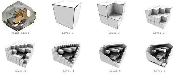
Managing millions of points at once is inefficient for all user types. Therefore, software often groups points into a 3D grid of boxes called “Voxels.” An Octree then organizes these Voxels into a hierarchy, allowing the computer to render only the details currently visible to the camera. As a result, this significantly speeds up the visualization of point cloud scans.
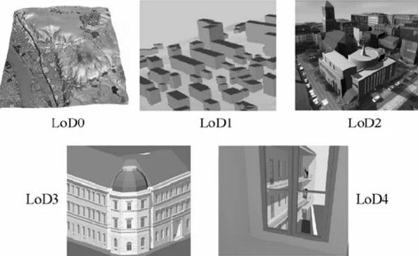
3. Level of Detail (LoD) Scaling
This technique adjusts the density of the point cloud model based on the viewer’s distance. If a scanned building is far away, the software renders only a few thousand points. As the camera moves closer, the software dynamically adds more point cloud data to reveal finer textures and edges.
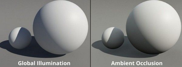
4. Shading and Ambient Occlusion
To make a point cloud model look realistic, software estimates shading around each visible point. Ambient Occlusion is particularly important, and it adds soft shadows in the cracks and crevices of the scan. This helps the human eye perceive precise depth and volume in what would otherwise appear flat as a cluster of dots.
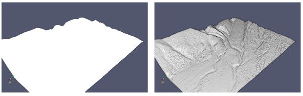
5. Eye-Dome Lighting (EDL)
EDL is a non-photorealistic shading technique designed specifically for point-cloud scanning results. It highlights the edges of objects within the cloud by darkening the surrounding pixels. Thus, this makes it easier for beginners and architects to distinguish between different objects in a complex, monochromatic scan.
5 Common Uses of Point Cloud Technology
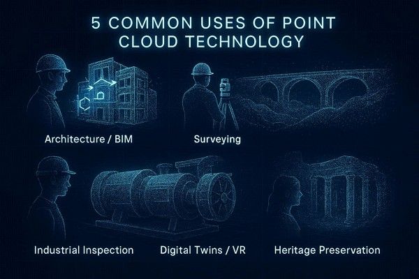
From historical preservation to high-tech manufacturing, point cloud technology is used whenever precision is a requirement. So, while learning what a point cloud is, review the 5 main ways professionals use these datasets:
1. Architecture and BIM
Architects and engineers use point clouds to capture the precise “As Built” conditions of existing structures. These scans are converted into detailed BIM models to identify potential design clashes and plan renovations with extreme accuracy.
2. 3D Surveying and Infrastructure
Civil engineers rely on dense datasets to create 3D maps of terrain, bridges, and large utility networks. This technology supports critical tasks like volume calculations for earthworks and long-term deformation monitoring of roads.
3. Industrial Inspection
Factories use the point cloud data to record the exact geometry of complex machinery and production lines. As a result, engineers can perform inspections and plan equipment retrofits dimensionally without shutting down operations.
4. Digital Twins and VR
Point clouds also serve as a geometric foundation for creating immersive VR experiences and realistic digital twins. Thus, these virtual replicas allow remote teams to conduct safety training and walkthroughs within a highly accurate digital environment.
5. Heritage and Archaeology
Specialists document ancient monuments and fragile artworks with sub-centimeter details for digital preservation. These 3D records enable deep research and virtual public access without causing physical wear and tear on historical sites.
5 Challenges of Working with Point Cloud Data
While point cloud scanning offers incredible details, the sheer scale of the data created several technical hurdles. In addition, handling millions of coordinates requires specialized strategies to ensure a smooth workflow. So, if you plan to use this technique, here are 5 challenges you need to be aware of:
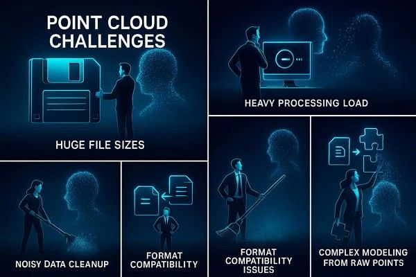
1. Massive File Sizes
A single point cloud scan can contain billions of points, resulting in file sizes ranging from hundreds of gigabytes to several terabytes. Thus, storing, transferring, and backing up these large datasets requires high-capacity hardware and high-speed networks.
2. High Computational Demands
Processing and rendering a 3D point cloud puts extreme stress on CPUs and GPUs. In fact, standard workstations often struggle to display the data without significant lag, necessitating high-end hardware or innovative point-cloud software to manage the load.
3. Data Noise and Artifacts
Scanners often capture “Noise,” stray points caused by reflective surfaces, moving objects, or atmospheric dust. Hence, cleaning this point cloud data is a time-consuming, manual, or semi-automated process that is required to ensure the final point cloud model is accurate.
4. Integration and Compatibility
Different point cloud scanner brands often use proprietary file formats. So, converting these into a unified format compatible with CAD or BIM platforms can lead to data loss or alignment errors if not handled carefully.
5. Complex Feature Extraction
Turning a raw point cloud into usable geometry, such as a flat wall or a cylinder, is technically challenging. Hence, software must guess where a surface begins and ends, which often requires human intervention to ensure the final model reflects reality perfectly.
Rendering Point Cloud Scenes Explained
Converting a point cloud scan into a polished cinematic or technical render is a multi-stage process. Since a 3D point cloud is a massive list of coordinates rather than a solid object, the computer must work harder to visualize the data accurately. So, glance at the mentioned point cloud rendering process with detailed optimization techniques and hardware requirements covered:
Hardware Considerations
Before processing the point cloud data, ensure you have these specialized components:
- RAM: Large datasets must be loaded into memory, so 64 GB to 128 GB is often the minimum for professional work.
- VRAM: A high-end GPU with substantial video RAM is required to render millions of points in real time.
- Storage: Fast NVMe SSDs are required to read and write the massive file sizes generated by point cloud services.
Workflow: From Raw Scan to Final Render
To know how to transition from field data to a finished visual, here is the workflow you need to follow:
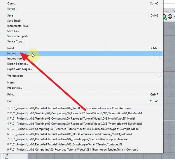
Step 1: Take Rhino 8 as an example and import the LiDAR/photogrammetry data into your processing tool by pressing the “File” and “Import” buttons. Scale the model if it appears too small and align it to the ground plane.
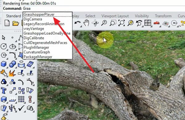
Step 2: Now, to create physical points on the surface, open the “Grasshopper” by searching for it in the command line. Create a new document, collect data for the added point cloud, and search for the “Point Cloud” parameter.
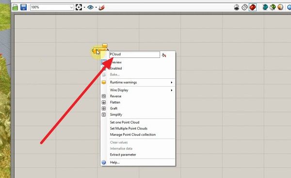
Step 3: Right-click it and select the “Set one Point Cloud” option to link your Rhino file.
Step 4: In the Grasshopper, use the “Reduce Point Cloud” and “Point Cloud Attribute” nodes.
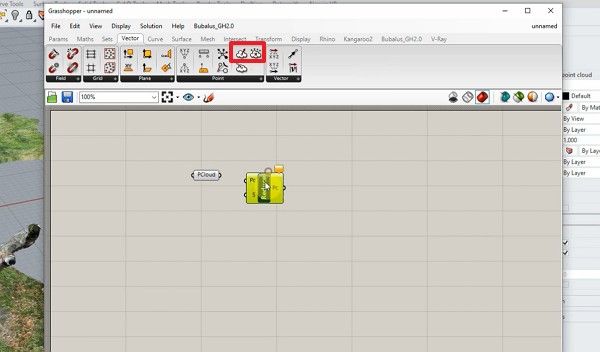
Step 5: Later, attach the “Panel” node with a number, such as 500 or 1000, to the “Samples” input. This prevents your computer from crashing by limiting the points being processed.
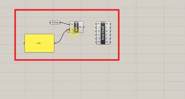
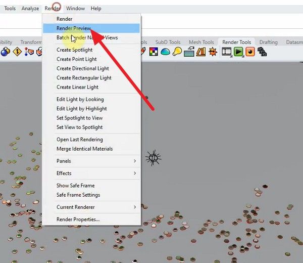
Step 6: Add the “Circle” node and connect the “Point” output from your Attribute node to the “Plane/Base” input. After connecting all the nodes, click the “Render Review” button under the “Render” section. Since the points are now physical surfaces, they will interact correctly with lightning and cast shadows.
Optimization and Rendering Techniques
To prevent system crashes during rendering point clouds, follow the mentioned methods:
- Decimation: Reduce the total number of points in areas with low detail while keeping high density for complex features.
- Clipping Volumes: Render only the specific section of the point cloud model that is visible in the current camera frame.
- Subsampling: Create lower-resolution versions of the dataset for real-time viewport navigation, saving the full-resolution data for the final output.
- Using Render Farms for Large Datasets: Even with a powerful workstation, rendering a complex point cloud scan animation can take days. Thus, use render farms like Fox Renderfarm to distribute frames across many nodes so that complex point cloud scenes and animation render easily. Additionally, with support for major DCC tools and render engines, you can keep your existing pipeline.
Conclusion
To wrap up, point cloud technology allows for unparalleled precision in digital twin creation and spatial mapping. Therefore, this guide has explained how to handle massive 3D point cloud datasets and where to use them while following the optimization techniques. For professional-grade results without straining local hardware, leveraging Fox Renderfarm processes heavy point-cloud animations. This turns complex raw data into stunning, high-quality renders.
Frequently Asked Questions
1. Can I convert a point cloud to a 3D mesh?
Yes, using a point cloud software, you can perform surface reconstructions to wrap a mesh around the points. Consequently, this will make it compatible with standard 3D animation tools.
2. What is the difference between LiDAR and a Point Cloud?
LiDAR is a hardware technology that uses laser scanning to collect data. On the contrary, the point cloud is the resulting digital dataset of 3D coordinates.
3. Is point cloud data accurate?
Yes, it's highly accurate and professional point cloud scanner equipment can capture data with millimeter-level precision. Thus, this makes it the standard for engineering and architectural surveys.



 Ryan Thompson